
REFLECTIONS UPON THE ARCHIVAL EXPERIENCE: MAPPING CONNECTIONS AND DISCONNECTIONS IN THE LATE SIXTEENTH CENTURY BORDERLANDS OF THE SOUTHEAST OF CHARCAS —PRESENT-DAY BOLIVIA—
- geopam

- 24 jun 2025
- 3 min de lectura
Mario Graña Taborelli
Fellow, University College London | GEOPAM

The most recent gathering of GEOPAM took place in Seville, a city that also hosts one of the most prominent repositories of records of the Early Modern Iberian Worlds: The Archivo General de Indias (AGI). One could literally spend a whole life perusing through thousands of dusty yellowish documents hosted in this archive. And indeed, the gargantuan task of doing research in the centuries-old building of one of the most beautiful cities in the world, which every year attracts historians and genealogists, alongside members of the public with a genuine curiosity for the past, can be time-consuming as well as rewarding. There are plenty of “eureka” moments for anyone prepared to spend time in the AGI. Finding a small -or large- piece of information can, sometimes, mean a breakthrough. More importantly, it is to connect that “glimpse into the past” with events, peoples, geographies and objects.

The “gates” to a world of, one always hopes, breakthroughs! The author is outside the archive. Photo taken in November 2024.
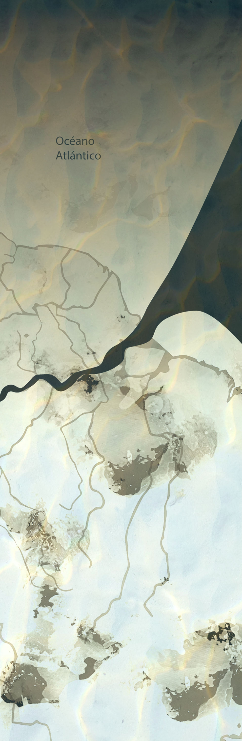
Connecting a map of the late sixteenth century Charcas borderlands that historians are well acquainted with -available here-, with a whole “environment of documents” of the time, was one of my “eureka moments” in the archive. Suddenly, the map “made more sense.” Commissioned by the President of the Royal Court of Justice or Real Audiencia in Charcas, Juan López de Cepeda, who sent it with a letter to King Philip II in 1588, it shows a frontier world. Whoever drew it was imaginarily standing looking down eastwards. The map points to what was known as the “North Sea” or the Atlantic Ocean -as opposed to the “South Sea” or the Pacific Ocean. This early Charcas was divided in this map into two sections separated not, as one would expect, by the Andes but by another “cordillera” known as “Cordillera de los Chiriguanaes” at the time. Beyond that “barrier” was the world of these Guaraní-speaking natives with their four settlements of five hundred “Indians each” -as the map indicates-. In a simple view, this is a map of “them and us.” It is mapping alterity. Or is it?
Finding references to long-lost “political love letters” between two Chiriguana chiefs and a Spanish Captain during the 1580s allowed me to bring together some of the details in that map and my new archival records. I was able to experience and understand the map differently. My attention suddenly shifted to connections instead of divisions, crisscrossing the space: dots that linked Spanish towns and Chiriguana settlements. Rivers ran across the rugged terrain, crossing boundaries. Trees everywhere, showing the district’s vast natural wealth. These small marks were telling a different story, one of disconnections as well as connections that should not only be read against the backdrop of alterity. These, now visible landmarks, spoke about mobilities, circulation, exchanges, conversations, visitations, agreements -and disagreements-, navigation and long walks. The map became dynamic, dynamising my own research.
These new connections, and disconnections, reveal a story of complex relations that we, as historians, can sometimes only find in archives and one that we are only beginning to unfold.
About the author
Mario Graña Taborelli is a historian of the Early Modern Iberian Worlds whose research centers on political cultures, locality, and legal history. He is a visiting fellow at University
College London (UCL) (2024-2025), an associate fellow of the Royal Historical Society of the United Kingdom, and a member of the Society of Latin American Studies. He graduated with a PhD from the University of London in 2022. His latest articles were published in The Sixteenth Century Journal “Juan Lozano Machuca and the Construction of the Global Spanish Monarchy in the Sixteenth Century” (LVI:1) February 2025 https://doi.org/10.1086/733573; and Itinerario, Journal of Imperial and Global Interactions “To Keep the Land Populated. Localising Empire and Constructing Locality, in the Sixteenth Century Charcas Frontier” January 2025. https://doi.org/10.1017/S0165115324000354
His first monograph “Jurisdictional Battlefields: Political Culture, Theatricality, and Spanish Expeditions in Charcas in the second half of the Sixteenth Century”, Liverpool University Press, 2024 and is Open Access: https://www.liverpooluniversitypress.co.uk/doi/book/10.3828/9781835537091


Esta obra está bajo una Licencia Creative Commons Atribución-NoComercial-CompartirIgual 4.0 Internacional.


Comentarios